Avalanches!
- Fabian Seymour

- Jan 7, 2024
- 9 min read
Winter is magical. Or at least it can be. We don’t really get ‘proper’ snow in the lowlands anymore in Britain. I can only remember a handful of cold Christmases and only one ‘proper’ white Christmas (in 2010 when I was living in Durham). When it falls in the lowlands or towns and cities, it’s normally a thin coating that lasts until rush-hour before it melts and turns to brown slush. Sometimes it can turn to black ice, but the classic snowy cottage looks are rare events these days.
Snow in the mountains however is about as close to proper winter that we can get in Britain these days. Even so, over the past 20 or so years that I’ve been mountaineering in Scotland in winter, I’ve seen stark decreases in the number of ‘decent’ winters, more unpredictability in snowfall, and erratic timings.
That said, it’s those blue-sky days later in the season when the snowpack is matured and consolidated that can provide the best climbing days or just hiking days out. Daylight is increasing rapidly, and the worst of the winter storms are behind us.


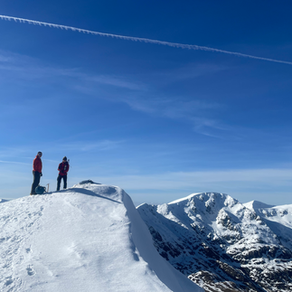


(Top 3 images are from the Mamores, the bottom three from the Grey Corries)
But we’ve still got winter to get through and conditions can change incredibly fast. Winters in the highlands of Scotland can still be brutal. A calm sunny morning can quickly deteriorate into a brutal storm with no visibility, complete white out, severe gale force winds and serious threat to our survival. Avalanches are an almost ever-present danger somewhere wind is relocating snow.
In Scotland, we don’t tend to get the fluffy alpine avalanches. We get huge heavy slabs of snow breaking loose that can be enormous. I’ve set one off myself many years ago. I was lucky riding the top of it. And it didn’t go far. But it could have easily covered a tennis court. Even if you are only interested in heading out in good weather, the weather can change. Even on a blue sky day, strong wind can whip ground snow up and create white-out conditions.
Complexity in Planning
Weather Forecasts
Heading out in winter involves so much more than just some fun learning about how stomp around in snow or how to ice axe arrest (something that needs dedicated practice to get good at - and the hope you’ll never have to use it). It all begins in the weeks and days leading up to your days out. What has been happening with the snow? Where is it? Where has it been accumulating? Where are the scoured areas?

Coire an t-sneachda in the Cairngorms. A classic classroom for winter skills courses
Planning is absolutely everything. If you’re still learning how to use the tools and walk efficiently on snow, then you can find areas where you don’t need to go far from the car park to practice. Even so, if the weather changes, wind picks up, you can find yourself in white-out conditions very quickly where you can’t even determine what’s up or down. Snow picked up off the ground can turn a cloudless day into a whiteout very quickly. So, you really do need to plan your day far more than you perhaps would in summer.
The weather forecasts from different providers will often disagree somewhat. I use a number of different forecasting sites. I’ll often take a bit of an average. I won’t just go with the one provider who is giving me the most favourable forecast for that day.
I will always look at The Mountain Weather Information Service. They have adjective descriptions for their forecasts and know the terrains in which they are forecasting. They know about the little peculiarities of the regions. Their Cairngorms & Mondaliath forecasts for example will often say “east of the A9 road it’ll be doing this and west of the A9 it’ll be doing something else". I’ve heard people asking “how does the A9 affect the weather?”
It doesn't. But the road was built through a huge glen snaking up from the south to Inverness that made sense for road building. This huge Glen separates the central highlands from the eastern and the different mountain ranges have different weather patterns.
The limited disadvantage about the MWIS is that they won’t tell you what the weather will be doing – something I find useful not just in summer. But you'll find the latest MWIS forecasts up pretty much everywhere in regions where they provide forecasts (gear shops, hostels, hotels, B&Bs, restaurants etc).
The Met Office gives mountain area forecasts as well as summit specific forecasts. I also use Yr.No, which also gives summit specific forecasts. Both will tell you what the weather will be doing over night.
Please note that during really unsettled conditions, the forecasts issued one hour may change completely within the next hour and so on, making it difficult to plan anything.


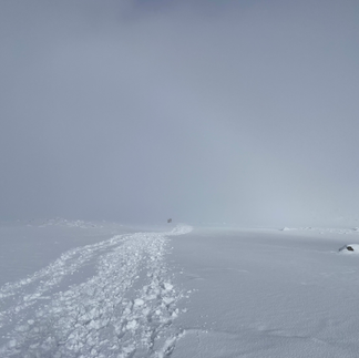
Separated by just a few hours. Near white-out conditions versus some blue sky creeping in!
Avalanche Forecasts
On top of the weather forecast, the avalanche forecast is issued for select regions in Scotland by the Scottish Avalanche Information Service. Formats have changed somewhat over the years but there is typically a written description, links to the previous day (which can have a huge bearing on the forecast) and the famous colour coded avalanche rose. I’m not going to go into full detail about interpreting these, we cover these on winter skills courses in detail. By going on a course, you can take the classroom study out on the mountains and begin to add contextual experience to your knowledge base.

An example of an avalanche forecast - this is for 7th December 2023 in the northern Cairngorms. (c) Scottish Avalanche Information Service.
I’ve heard numerous anecdotes about the avalanche rose and the forecast. For example, some research had shown people spent about 15 seconds looking at the rose on average. Some people believed that an entire side of a mountain was off limits with particular forecasts and risks, others chancing it because “I’ve been there loads of times before”. There is a lot of information given in these forecasts and it is important to really scour and absorb all of the information.
The avalanche rose and written descriptions will give you a good indication of where the main risk areas are – which side of the mountains and from what height. There are three numbers given on the rose – the highest summit in the area, the ‘change zone’ where the danger begins (and this will vary) and the lowest outer number is more or less the snow line and this can also change daily. The colour codes all come with a written description. For example, orange is described as having a ‘considerable’ risk.
Combining your information
So there is a plethora of of information available to you. We’re not forecasters ourselves, so there’s a limit to what we “need” to know. But we can access it in our hotel wherever we like on our phones. There is now a ‘Be Avalanche Aware’ app that you can download to Android or Apple devices that will ping you when you reach an avalanche area, with forecasts, explanations, videos and lots to explore to help you understand how snowpacks change.
Gone are the days when all we had on our club trips was the shipping forecast on a battery-powered radio, someone who could interpret it, and a discussion about what the snow pack was likely to be doing as a result.
I typically spend at least an hour each evening planning when conditions are changing or stormy. On top of a range of forecasts that are updated regularly, we are helped these days by apps such as Fatmap which will show you areas on the map where the slope angle is between 30-45 degrees and therefore where the avalanche risks could be (it will show all possible angles between 30-45 degrees, bearing in mind you need to include the avalanche forecast to determine which side of the mountain the risk is and at what height).

An example of the northern corries in the Cairngorms showing the avalanche prone slope angles in yellow - orange - red. (c) Fatmap.
I will read both the weather and avalanche forecasts. And then re-read them and look at a map of the area I’m intending to head to. Mostly in winter, it’s roughly the same area where I’m teaching. So, I get to build up a good working knowledge of what’s looking workable and areas I don’t want to go anywhere near. But I do work elsewhere and do some guiding and that can take me anywhere.
Putting it all together is the real skill that comes with experience. In Britain, we predominantly get winds from the south west. This results in snow that’s fallen on the SW slopes being picked up and deposited on the north eastern slopes and edges creating cornices and unstable deeper snow-packs (windslab). It’s also important to remember that avalanches typically happen between 30-45o. So even if you have a considerable avalanche risk on a NE slope of a mountain, if you are on a scoured ridge you should be able to avoid it or if you’re on a large sloping mountain with a gentle gradient all the way up, the angle just won’t be steep enough to avalanche. This is a very simplistic summary – but the essence is that there are almost always safe routes somewhere. But again, building in that picture of what has been happening in the snowpack with the weather and avalanche forecasts, and a map is vital. If you don’t have the experience, go on a course, refresh your knowledge if you have, and go out with guides or more experienced club members.
Heuristic Traps
Most people who get avalanched set off their own avalanches. It’s statistically true (data can be obtained from mountain rescue) as well as anecdotally true. There are heuristic traps that we can fall into – decision making traps.
We will explore these on courses. I like using FACETS to describe these human heuristic traps:
Familarity – we’re familiar with an area, so begin to ignore risks. Been there before, done that before, it was fine.
Acceptance – “You’re not part of the club unless you’ve climbed this route”. Anything really that makes us think we’ll get noticed or respect from our peers. The determination to be accepted may make us take risks we really wouldn’t otherwise given a particular forecast.
Commitment – I think we’ve all done this. “I’ve waited ages to get here and do this”. “I’ve driven all this way”. “I’m only here for two days”. Well so be it. It may only be that Munro you need to bag in the area, but if it’s an avalanche waiting to happen, just go and do something else. It’ll still be there long after everyone currently alive has passed on.
Expert Halo – I might be the guide / instructor for the day, and while it’s true I’ve gained a lot of experience in the mountains in winter, been on numerous courses about snow and avalanches, done my winter mountain leader etc., I’m only human and can also fall into heuristic traps. If anyone in my group is feeling uncomfortable with the snow I encourage people to speak up. We all have a survival instinct. I will always stop and consider and re-assess. It is no bad thing to stop and consider “hmmm, what is it that has made this person nervous” and assess where you are.
Tracks – “There’s footprints, others have been here already, must be safe” or “I’m determined to get a fresh backcountry ski run rather than where everyone else has compacted the snow”. Walkers tend to fall into the former category as breaking trail is HARD WORK! Just because others have been there doesn’t make it safe. They could have weakened the snow to the point it just needs one more person to walk it before the side of the mountain goes down.
Social facilitation – The higher the experience or confidence in the group, the more risks may be taken.
Always remember - They are still just forecasts
I’m going to finish off with a story. In January 2018 I was with someone who I didn’t know too well (back then). We were new friends with a shared drive going for our winter mountain leader assessments. We decided to go and do the winter traverse of Liathach in Torridon. It was a clear day, and the avalanche forecast was in our favour. Completely green for 360o. Heading up the track below the snowline, the sun even felt a bit warm on the few bits of exposed skin. We arrived in the corrie and the snowline. It looked absolutely incredible. The contrast of white snow, black cliffs and blue sky. Then I saw some snow sloughing off. It didn’t look much until I realised how far off it was. I then looked up at the gully we were due to go up and thought “that’s absolutely loaded”. I just got a bad feeling about it and felt nervous about it. It looked to me like it was waiting for someone to get beneath it before avalanching.
We carried on a bit both talking aloud about the conditions. On hind sight, I realise we were both trying to justify carrying on but both realising the conditions weren’t right. Neither of us wanted to be the first to say it.
Then we saw another couple below some cliffs narrowly avoid getting buried in another avalanche. Indeed, the snow was sloughing off so regularly now that I managed to film one. And still, neither of us wanted to say ‘let’s do this another day’. We eventually did – but this was two people, winter ML trained falling into several heuristic traps (any guesses which ones?). The sun was warming the steep steps of Liathach. It’s a peculiarity of the area and the terrain. Typically the route up is on the southern aspects that were being warmed by the sun causing some sloughing.
The take home message is that the information given to you are forecasts. They are usually extremely good, but they are forecasts and you have got to build up experience for yourself and also go with gut instinct. If something isn’t right don’t do it. Or turn back.


Comments